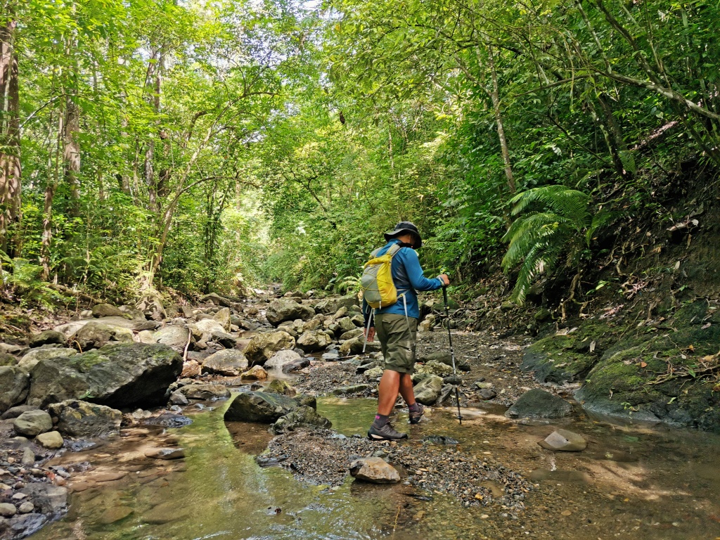
Planning to explore Cebu’s hiking spots? You’ve come to the right page. Yes, Cebu is not just all about beaches and resorts. Despite its reputation as an island paradise, Cebu is home to numerous mountains and peaks that beckon adventure enthusiasts. Whether you’re a seasoned trekker or a novice hiker, Cebu offers trails suited to various skill levels, promising unforgettable experiences amid stunning natural landscapes.
Cebu’s got something for everyone, whether you’re a seasoned hiker or just starting out. From the iconic Osmeña Peak to hidden gems like Mount Manunggal, there’s a trail calling your name. And the best part? You don’t have to be that ‘harkor’ to enjoy it. So, why not take a break from the usual tourist spots and dive into Cebu’s best hiking destinations? Trust me, you won’t regret it!
Quick Guide to Cebu Mountains: Ultimate Guide to Hiking in Cebu
- Osmeña Peak (Badian)
- Sirao Peak (Cebu City)
- Bocaue Peak (Cebu City)
- Babag Range (Cebu City)
- Chalet Hill (Cebu City)
- Mt. Naupa (Naga City)
- Lanigid Hill (Liloan)
- Mt. Bandilaan (San Fernando)
- Puting Bato (Toledo City)
- Calbasaan (Minglanilla)
- Mt. Lantoy (Argao)
- Tiposo Peak (Argao)
- Mt. Lanaya (Alegria)
- Mt. Manunggal (Balamban)
- Mt. Mauyog (Balamban)
- Mago (Danao-Carmen-Tuburan)
- Mt. Kapayas (Catmon)
- Mt. Manghilao (Danao)
- Cansomoroy (Balamban)
- Mt. Hambubuyog (Ginatilan)
- Mercado’s Peak (Badian)
- Casino Peak (Badian)
- Tagaytay (Toledo City)
- Candongao (Badian)
- Pandung Bato (Toledo City)
- Camari Hill (Carcar City)
- Calibasan (Toledo City)
- Mt. Binalabag (Argao)
- New Bucao (Toledo City)
- Ablayan Peak (Boljoon)
- Danasan Peak (Danao City)
- Spartan Trail (Cebu City)
- Udlom Peak (Dalaguete)
- Pangilatan Peak (Naga City)
- Magdook (Naga City)
- Dakung Krus (Compostela)
THE BEST HIKING DESTINATIONS IN CEBU
Need a breath of fresh air and a dose of nature’s therapy? Cebu’s stunning mountains is the ultimate escape. Trust me, it works wonders! Whether you’re seeking clarity or just need a break, these hiking spots have got your back. So, lace up those trail shoes and trekking sandals, hit the trails, and let Mother Nature work her magic on you. You’ve got this!
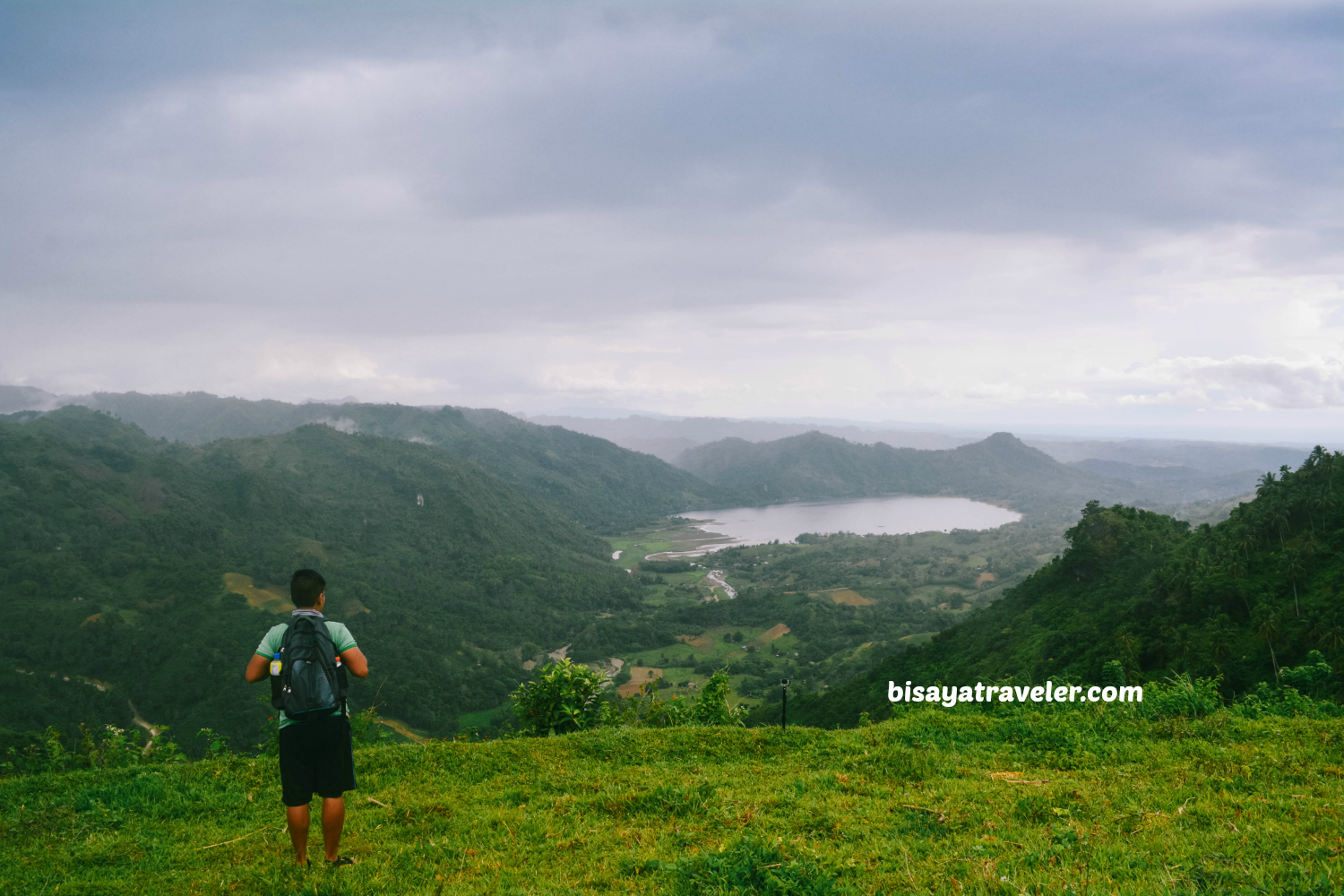
1. Osmeña Peak
You’ve probably heard that no beginner mountain climber’s journey is complete without conquering Cebu’s highest peak, Osmeña Peak. It’s practically a rite of passage for every Cebuano adventurer. Why? Well, besides treating you to breathtaking vistas of neighboring mountain ranges, Osmeña Peak serves as a gateway to incredible side trips. From the enchanting Kawasan Falls to the picturesque Casino Peak, there’s a whole world of nearby tourist gems waiting to be explored alongside this majestic summit.
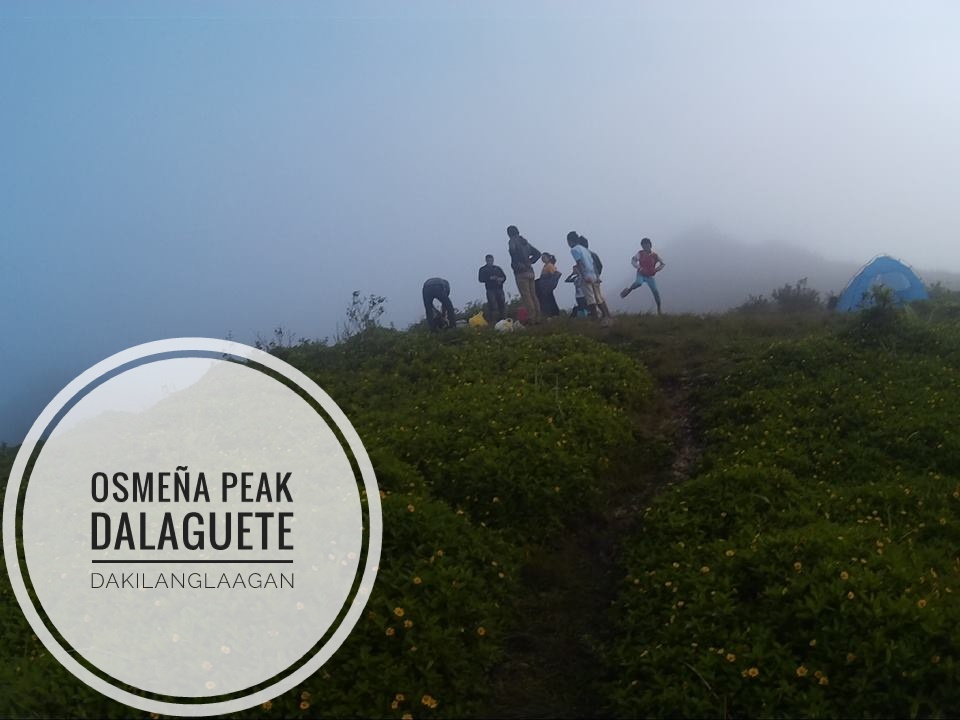
Where is Osmeña Peak Located?
Osmena Peak is conveniently reachable via Mantalongon, Dalaguete, yet it falls under the political and geographical boundaries of Badian town.
How to Get to Osmeña Peak?
To begin your journey to Osmena Peak from Cebu South Bus Terminal, hop on a bus headed to Dalaguete. Once there, seek out a habal-habal driver who can take you to the drop-off junction for Osmena Peak. From the junction, you have to register and hire a local guide to help you get to the summit.
Expenses:
- P100.00 – P120.00 Bus fare to Dalaguete
- P100.00 – Habal-habal fare to Osmena Peak.
- P30.00 – Entrance fee
- P50.00 – Camping FeeTotal: P500.00 plus (Food and expenses to the traverse to Kawasan Falls has not been included)
- NOTE: Rates are subject to change without prior notice.
Tips:
- A bus service operates directly from Cebu City to Mantalongon, Dalaguete, with a stop at the Caltex Gasoline Station in Carbon. While the fare is more budget-friendly, please note that air-conditioned buses are not currently available.
- Guide fees are now established as mandated with LGU. If you feel more generous, you can give tips as well to your guide.
- Following your time at the peak, you have the option to embark on a four to five-hour traverse to Kawasan Falls, depending on the group’s pace. Alternatively, you can choose to return to Dalaguete town proper.
Read on for More Details about Osmeña Peak:
Osmena Peak: Conquering Greater Heights
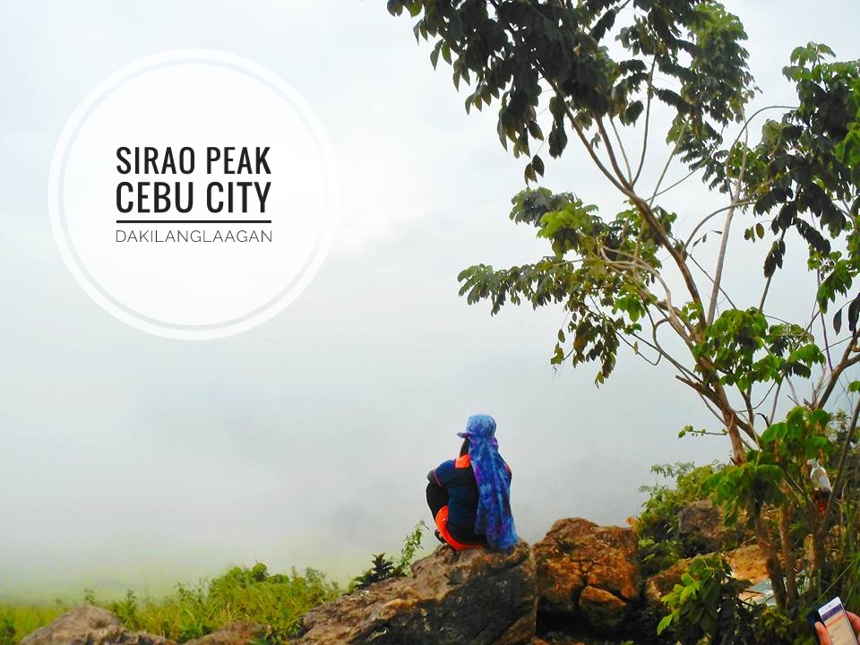
2. Sirao Peak
Sirao Peak stands as a beloved hiking destination for many climbers in Cebu, easily accessible from the heart of Cebu City. Featuring a network of trails leading to the summit, ranging in difficulty from easy to challenging, it caters to hikers of all skill levels.
Unfortunately, the summit of Mt. Kan-irag is no longer accessible for hikers. However, camping is still permitted in designated areas allowed by the management.
Where is Sirao Peak Located?
Sirao Peak is nestled in the picturesque area of Kan-irag, which is located in Cebu City. This enchanting peak offers panoramic views of the surrounding landscapes, making it a popular destination for outdoor enthusiasts and nature lovers alike. With its lush greenery and serene atmosphere, Sirao Peak provides the perfect backdrop for memorable hiking adventures and tranquil moments of contemplation amidst the beauty of nature.
How to Get to Sirao Peak?
There are multiple trails leading to Sirao Peak, offering various options for hikers. However, the easiest and most accessible route is through the backdoor via Ayala Heights, followed by a short hike to the peak. Here’s a step-by-step guide:
(1) Begin your journey from JY Square Mall, Lahug, Cebu City, where you can catch a habal-habal ride bound for the base of Sirao Peak.
(2) Once you arrive, embark on a brief 5 to 20-minute hike to reach the summit of Sirao Peak.
Expenses:
The first time I visited Sirao Peak, I only spent P20.00. To my surprise, my second trip cost me just P15.00! However, if you choose the easiest route mentioned above, be prepared to pay between P75.00 and P150.00 per habal-habal ride.
Alternatively, if you’re up for a challenge and want to join the adventurous runners aiming for mileage, you can even run from JY all the way to Sirao’s campsite.
Tips:
(1) If you choose alternative trails, you can explore the renowned heart-shaped pools, Budlaan Falls, and Tinisig-uwang Falls. Check the link below for details.
(2) Just a few meters away from the peak lies the “Amsterdam of Cebu” or the Sirao Celosia Flower Farm, perfect for stunning photo shoots.
(3) Feel free to pitch your tents and enjoy an overnight stay at the designated camping site for a minimal fee.
Read on for More Details about Sirao Peak:
- Trails and Tales of Sirao Peak
- Kabang Falls and Sirao Peak: Urban Trekking and Friendship Building
- Sirao: More than just the flowers
- Mt. Kan-irag: Perks of Traveling in Groups
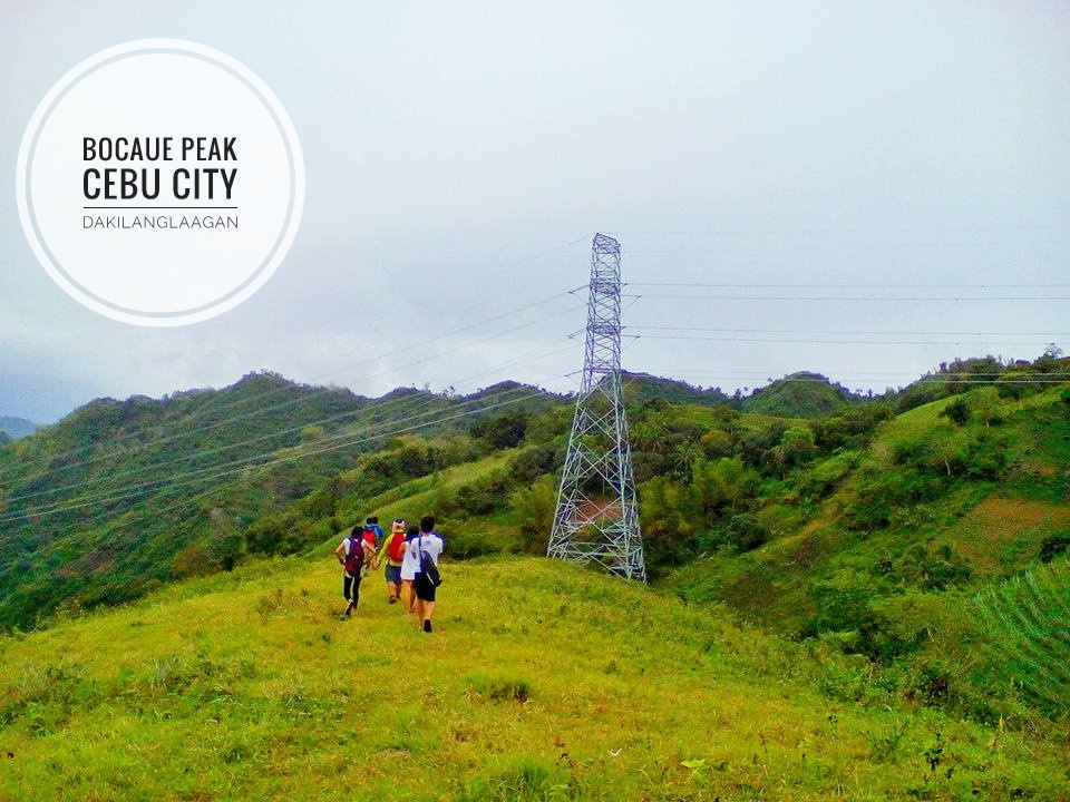
3. Bocaue Peak
If you’re seeking more challenging routes, you’ve likely heard of Bocaue Peak. Nestled in the highlands of Cebu City, this destination has become a camping favorite among outdoor enthusiasts and weekend hikers alike. Most recently, two campsites have been established in this area: Camp Adela and Chateau Blanc.
Where is Bocaue Peak Located?
Bocaue Peak is situated in the stunning locale of Bocaue, nestled within Barangay Pamutan, Cebu City. This captivating peak offers adventurers a glimpse of breathtaking vistas and serene surroundings, making it a sought-after destination for hiking enthusiasts and nature seekers.
How to Get to Bocaue Peak?
There are multiple routes to reach the peak, including the option to ride a habal-habal from the city. For those seeking a challenge, consider the following routes:
Route 1: Spartan Trail
Begin at Convergys, Banawa. Hike to Good Shepherd, then tackle Monterraza’s via direct assault. Descend to Buhisan Watershed with sidetrips to Bocaue Creek and Badiang Falls. Conclude with a final assault to Pamutan before reaching Bocaue Peak. Camping overnight at the peak is permitted, and currently, no entrance fees are enforced.
Route 2: Babag-Napo Trail
Start at Guadalupe Church and either hike or ride a habal-habal to Barangay Napo. From there, ascend to Babag before continuing on to Bocaue Peak.
Note that both routes are not recommended for beginners. However, if you’re up for the challenge, give it a try—just remember that these mountain ranges serve as training grounds for mountaineers preparing for major climbs.
Expenses:
P150.00 for habal-habal fare (depending on your haggling skills)
Tips:
(1) Consider joining practice hikes organized by Cebu-based mountaineering groups. They offer valuable expertise on the routes and serve as skilled moderators and facilitators during such events.
(2) Ensure you bring an ample supply of water. Both routes are exposed to direct sunlight, intensifying the trek’s physical demands.
(3) While water sources are accessible along the route, if you have a sensitive stomach, it’s advisable to bring several liters of water with you as a precaution.
Read on for More Details about Bocaue Peak:
4. Babag Range
Just a heads up if you’re new to hiking and your buddies want to tackle Babag: it’s just a heads up if you’re new to hiking and your buddies want to tackle Babag. Depending on how fast you go, Babag could take you anywhere from a couple of hours to a full day to conquer.
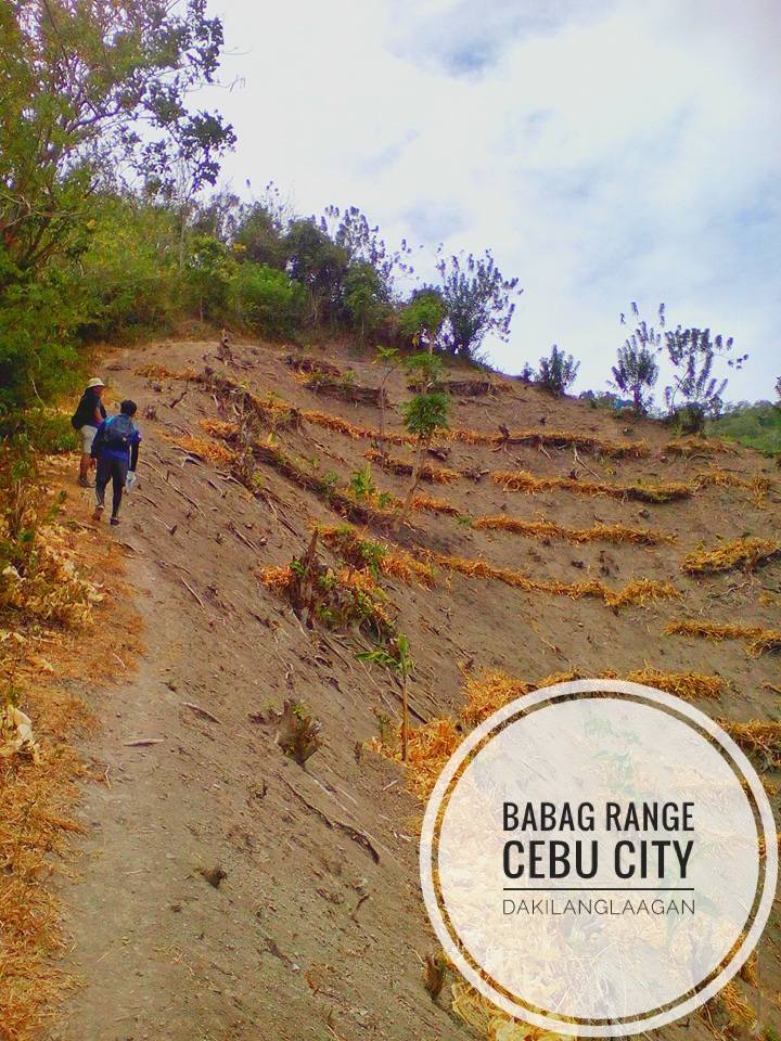
Where is Babag Range/ Mt. Babag Located?
Mt. Babag is situated in Barangay Babag, Cebu City. This scenic area offers hikers stunning views and diverse trails to explore amidst the natural beauty of Cebu City’s landscape.
How to Get to Babag Range?
(1) Meet-up at Guadalupe Church for the starting point of your hike.
(2) Take a habal-habal ride to Barangay Napo for convenient access to the trailhead.
(3) Start the trek to Babag mountain ranges. You may opt to continue onward to reach Bocaue Peak or exit to Temple of Leah.
Expenses:
P50.00 for habal-habal fare going to Barangay Napo (subject to change without prior notice)
Tips:
(1) Consider joining practice hikes organized by Cebu-based mountaineering groups. They possess intimate knowledge of the routes and serve as adept moderators and facilitators during such outings.
(2) Make sure you carry an ample supply of water. Both routes are exposed to direct sunlight, heightening the physical demands of the trek.
(3) While water sources are available along the route, individuals with sensitive stomachs may want to bring additional liters of water as a precaution.
(4) For those seeking an extra challenge, you can choose to extend your trek to Chalet Hill or Sirao Peak via the Malubog trail.
Read on for More Details about Babag Range:
5. Chalet Hill
Why endure stress when you can savor the mountains of Cebu without embarking on hours-long hikes? This is precisely why Chalet Hill holds a special place in the hearts of many campers. It provides a serene escape from the city crowds, allowing for cherished moments with a select few companions. With its panoramic view of the city lights, it sets the ideal ambiance for late-night conversations and moments of self-reflection.
Note: The owners of this site have implemented restrictions on camping.
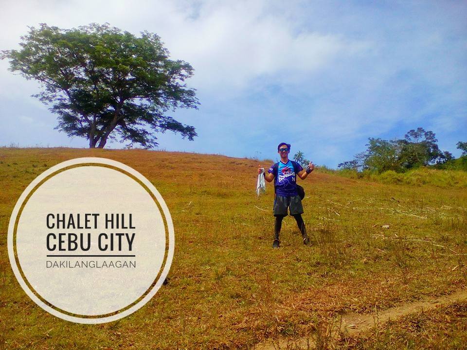
Where is Chalet Hill Located?
Chalet Hill? It’s tucked away in Barangay Busay, Cebu City. It’s a sweet spot for soaking in some stunning views and just chilling out surrounded by nature’s beauty. It’s a go-to spot for anyone looking to escape the hustle and bustle for a bit.
How to Get to Chalet Hill?
The most straightforward route to this cherished campsite, favored by many mountaineers, begins at JY Square. You can simply take a habal-habal ride directly to the hill’s base, with no trekking necessary.
But if you’re coming from Babag and exiting towards the Temple of Leah, you’ll pass by this area along the way.
Expenses:
P50.00 fare to Chalet Hill from JY Square. (Subject to change without prior notice.)
Tips:
Chalet offers a stunning panoramic view of the city, especially enchanting at night with the twinkling city lights. This captivating vista is one of the main reasons why many people choose to camp here.
Read on for More Details about Chalet Hill:
Trails and Tales to Sirao Peak
6. Naupa
Mt. Naupa is an ideal hiking destination for adventurers seeking breathtaking sunrise and sunset views. With its expansive camping site and relatively gentle trails, it offers a tranquil escape that can be explored in just an hour or two.
Where is Mt. Naupa Located?
Ah, you’re talking about Mt. Naupa? It’s right there in Naga City, Cebu. It’s a gem for hikers, offering stunning views and a peaceful retreat from the city buzz.
How to Get to Mt. Naupa?
(1) Take a jeepney headed for Tungkop, Minglanilla, located at the boundary between Minglanilla and Naga City. Look out for Tinong’s Bakery on the right and Julie’s Bakeshop on the left as landmarks.
(2) Hop on a habal-habal bound for Cogon Chapel.
(3)From the chapel, embark on a 45 to 60-minute hike to reach the summit.
Note: According to a local teacher, the perfectly-coned peak is Naupa, while the adjacent mountain offering views of Mt. Naupa is Mt. Luisa, as shared during our hike.
Expenses:
P10.00 – Fare to Minglanilla
P25.00 – Habal-habal fare to Cogon Chapel (Subject to change without prior notice.)
Tips:
(1) Opting for an afternoon hike to this scenic sanctuary is highly recommended, as it offers breathtaking sunset vistas for avid sunset chasers.
(2) Additionally, the night trek back to the chapel provides a captivating view of the starry sky, illuminating the trails.
(3) Recently, we embarked on a late-night trek and camped at Mt. Naupa, where we witnessed the spectacular sunrise from the summit. It was one of the most unforgettable camping experiences I’ve had, truly worth the adventure. I encourage you to give it a try as well.
Read on for More Details about Mt. Naupa:
7. Lanigid Hill
Lanigid Hill, nestled in Liloan, Cebu, offers a serene escape for nature enthusiasts and hikers alike. This scenic hill provides breathtaking views of lush greenery and panoramic landscapes, making it a perfect spot for relaxation and photography. Accessible via a short trek, Lanigid Hill offers a refreshing break from the hustle and bustle of city life. Whether you’re seeking a peaceful retreat or an adventure in nature, Lanigid Hill promises a memorable experience for visitors of all ages.
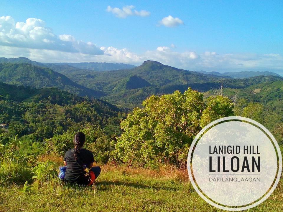
Where is Lanigid Hill Located?
Lanigid Hill is located in Liloan, Cebu—a great spot for taking in some awesome views and unwinding in nature’s embrace.
How to Get to Lanigid Hill?
(1) Catch a bus or jeepney heading towards Liloan.
(2) Upon reaching Jollibee in Liloan, hire a habal-habal ride to Barangay Lanigid or Barangay Mulao.
(3) Upon arrival, register at the Barangay Hall and pay the P10.00 registration fee.
(4) Begin the 500-meter trek towards the peak.
Expenses:
P15.00 – fare from SM to Liloan
P50.00 – motorcycle fare to Barangay Mulao (Subject to change without prior notice.)
Tips:
To amp up your adventure, why not venture further to Mulao River for an exhilarating river trek? Along the trail, you’ll discover awe-inspiring rock formations like the enchanting Stone Ark and Malingin Rock, adding an extra thrill to your journey.
Read on for More Details about Lanigid Hill:
- Lanigid Hill: Social Climbing101
- More reasons to visit Lanigid – Liloan Cebu
- 10 Things about Climbing Mount Lanigid
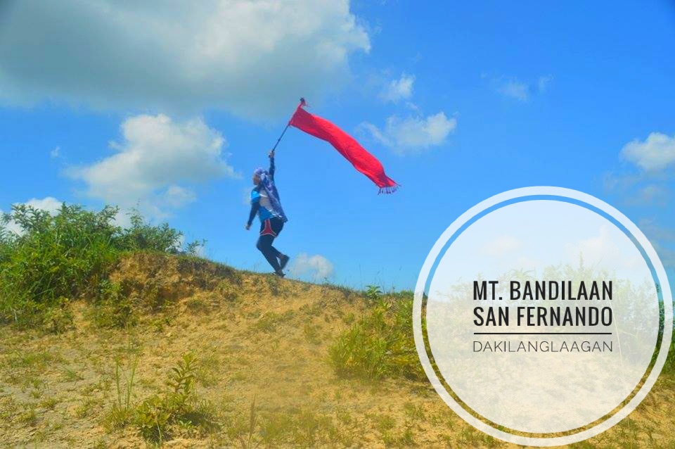
8. Bandilaan
Mount Bandilaan in San Fernando, Cebu, presents an enticing adventure for nature lovers and hiking enthusiasts. With its lush greenery and captivating landscapes, it offers a serene retreat from the hustle and bustle of city life. Whether you’re looking to challenge yourself with a trek to its summit or simply unwind amidst its natural beauty, Mount Bandilaan promises an unforgettable experience for all. Just be prepared for the heat along the open trail as you ascend towards the summit.
Where is Mt. Bandilaan Located?
San Fernando,
How to Get to Mt. Bandilaan?
(1) Head to Cebu South Bus Terminal and catch a bus heading to San Fernando proper.
(2) Upon arrival, arrange for a habal-habal ride to Barangay Bandilaan.
(3) Start your short trek to Mt. Bandilaan.
Expenses:
30.00 – bus fare to San Fernando
P30.00 – habal-habal fare to Barangay Bandilaan (Subject to change wihout prior notice.)
Tips:
(1) Bandilaan Peak is directly heated by the sun because it doesn’t have vegetation along the way; thus, it’s best to visit the place early in the morning or late in the afternoon.
(2) There are two caves that you can visit after spending some time at Mt. Bandilaan. Both are difficult to locate but feel free to ask locals around to lead the way.
Read on for More Details about Mt. Bandilaan:
9. Puting Bato
Puting Bato, nestled in the rugged terrain of Toledo City, offers a thrilling adventure for those seeking a challenge. Its trails are notorious for being difficult and rocky, testing the endurance and skills of hikers.
As you navigate through the rugged paths and steep inclines, the panoramic views of the surrounding landscape unfold, rewarding your perseverance with breathtaking vistas. While the journey may be tough, reaching the summit of Puting Bato is a triumph worth celebrating, making every step taken on its rocky terrain a testament to your determination and resilience.
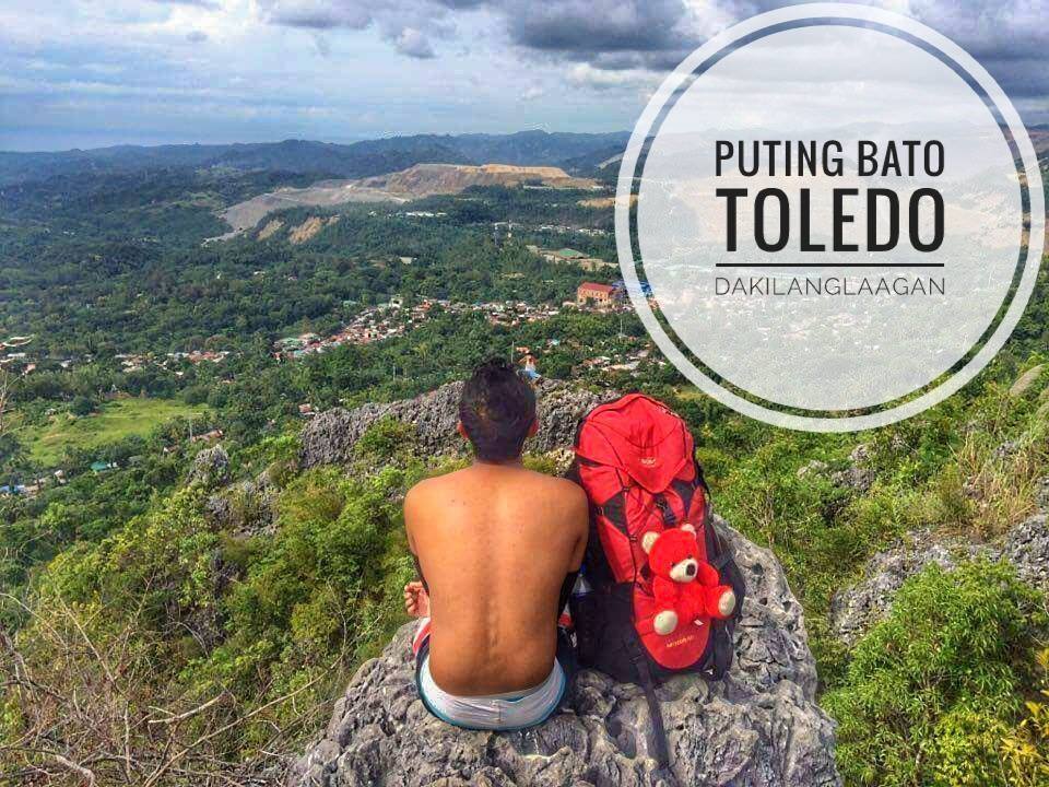
Where is Puting Bato Located?
Toledo City, Cebu
How to Get to Puting Bato?
(1) Hop on a bus headed to Lutopan Landing in Toledo.
(2) Arrange for a habal-habal ride to take you to the jumpoff area, where locals are well-acquainted with the trail leading to the summit of Puting Bato.
Expenses:
Bus fare to Lutopan Landing: P40.00
Habal-habal fare to Puting Bato jumpoff: P10.00
*Guide fee is negotiable.
Tips:
Toledo boasts numerous tourist attractions near the vicinity of Puting Bato. Consider adding Atlas’ Mining Pit (Biga Pit), the intriguing Maze Garden at Capilla Santa Ana in Sitio Santa Ana, and the nearby Seven Caves of Campo Siete to your itinerary for a well-rounded exploration experience.
10. Calbasaan
Nestled in the picturesque landscape of Cebu, Mt. Calbasaan offers hikers a breathtaking journey through its beautiful terrain. With its open trails winding through lush forests and verdant hillsides, the mountain presents a captivating landscape waiting to be explored.
As you trek along its open trails, you’ll be treated to panoramic views of the surrounding countryside, with each step revealing the natural beauty of the region. Whether you’re an experienced hiker seeking a new adventure or a nature enthusiast eager to immerse yourself in the splendor of the outdoors, Mt. Calbasaan promises an unforgettable experience amidst its stunning scenery and open trails.
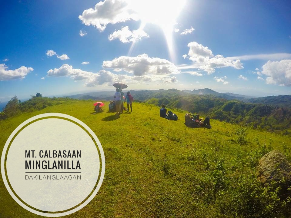
Where is Mt. Calbasaan Located?
Minglanilla, Cebu
How to Get to Mt. Calbasaan?
To begin your journey to Campo Otso (Camp 8) in Toledo, catch a bus from South Bus Terminal heading to Lutopan Landing Bus Stop. Upon arrival, arrange for a habal-habal ride to transport you to your destination.
Alternatively, you can opt to join hikes organized by groups such as Tribu Kutod or Pangilatan Unlimited Trail Adventures, which regularly host events and share invitations on their Facebook pages.
Expenses:
P40 – bus fare to Toledo
P20 – habal-habal to Camp 8
*Guide fee is negotiable. Fare is subject to change without prior notice.
Tips:
After descending from Mt. Calbasaan, you have the option to return to Toledo Proper and then head to Barangay Cantabaco for a thrilling rock climbing experience.
Alternatively, you can proceed to Camp 7 for an exciting caving adventure at the majestic White Cave. Please note that there is also a different trail starting from Minglanilla Proper, but it involves a longer hike and requires familiarity with the route.
Read on for More Details about Mt. Calbasaan:
11. Mt. Lantoy
Nestled amidst the verdant landscapes of Argao, Cebu, Mt. Lantoy beckons adventurers with its blend of legends and natural beauty. Its challenging trail, steeped in myths and stories passed down through generations, offers hikers a thrilling journey through dense forests and rugged terrain.
As you ascend the Mt. Lantoy, you’ll be enchanted by its breathtaking vistas and the sense of mystery that lingers in the air. Whether you’re drawn by the allure of its legends or the promise of an exhilarating hike, Mt. Lantoy promises an unforgettable experience for nature enthusiasts and thrill-seekers alike.
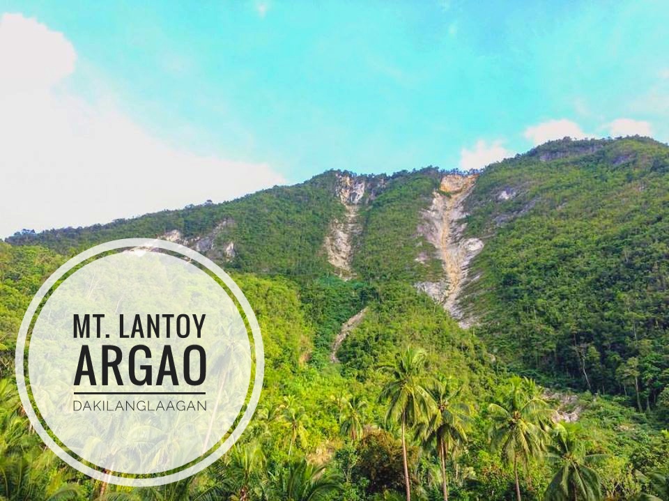
Where is Mt. Lantoy Located?
Argao, Cebu
How to Get to Mt. Lantoy?
First, catch a bus headed for Argao and upon arrival, make your way to the municipal hall of the town. There, you can inquire about hiring a guide who can provide you with directions and assistance for your exploration.
Expenses:
P80 – P100.00 – bus fare to Argao (Subject to change without prior notice.)
Read on for More Details about Mt. Lantoy:
12. Tiposo Peak
Situated in the heart of Argao, Cebu, Tiposo Peak boasts a captivating charm with its panoramic views overlooking the sea. As you ascend its slopes, you’ll be greeted by stunning vistas that stretch out before you, offering a glimpse of the beauty of the surrounding landscape. Whether you’re seeking a peaceful retreat or an adventurous hike, Tiposo Peak promises a memorable experience for nature lovers and explorers alike.
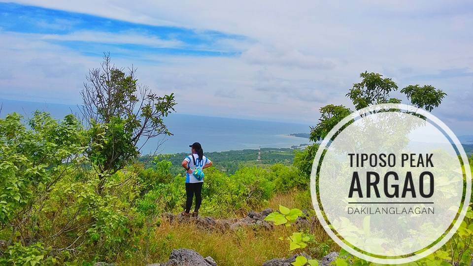
Where is Tiposo Peak Located?
Taloot, Argao, Cebu
How to Get to Tiposo Peak?
So, first things first, hop on a bus headed to Taloot Wharf in Argao. Once you’re there, just chat up the locals for directions to Liki Spring. If you’re feeling lazy or it’s a bit of a trek, you can always flag down a tricycle to take you to the jumpoff area. Then, it’s time to hit the trail and start that uphill trek!
Expenses:
P60.00 – bus fare to Argao
P10.00 – tricycle fare to Liki Spring
Rates may change without prior notice.
Tips:
(1) You have the option to arrange for a habal-habal ride directly to the base of Tiposo Peak, but if you’re up for a bit of adventure like we were, we started our trek from Taloot and trailblazed our way to Tiposo Peak.
(2) Along the highway, you’ll find numerous accessible springs where you can quench your thirst. Just muster up the courage to ask the locals, who are always eager to lend a helping hand.
(3) For a satisfying meal, head over to the Sutukil Restaurant near the wharf. They specialize in cooking dishes from freshly caught fish sourced from their own fish pens, ensuring a delightful culinary experience.
Read on for More Details about Tiposo Peak:
Tiposo Peak: Trailblazing to the Heart of Argao
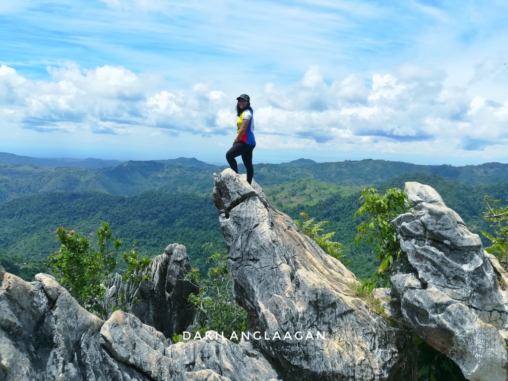
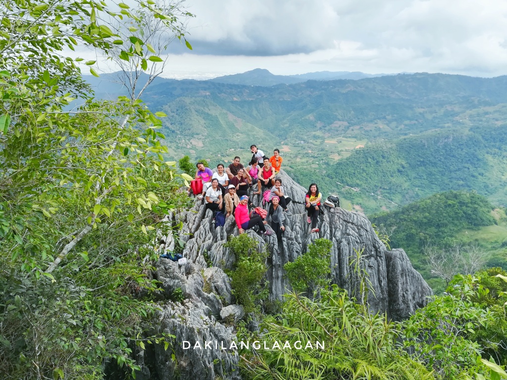
13. Mt. Lanaya
Mount Lanaya, situated in Alegria, Cebu, is a beloved destination for adventurers seeking both challenge and scenic beauty. Its rugged trails and steep ascents offer a thrilling experience for hikers, while its summit rewards with breathtaking views of the surrounding landscapes, including nearby peaks and the vast ocean beyond.
Renowned for its distinctive knife-edge ridge, known as Kalo-kalo Peak, Mount Lanaya beckons both seasoned mountaineers and nature enthusiasts alike to conquer its heights and revel in the awe-inspiring vistas it offers.
Where is Mt. Lanaya Located?
Mt. Lanaya
How to Get to Mt. Lanaya?
(1) Start your journey by riding a bus to Alegria town proper.
(2) Upon arrival, decide between the two trails leading to the summit of Mt. Lanaya: the Legaspi trail or Lumpan trail. If you’re short on time like we were, opt for the Lumpan trail, which only takes an hour to trek. You can arrange for a habal-habal ride to take you to the base of Mt. Lanaya via the Lumpan trail and seek directions from the locals.
(3) Keep in mind that there are strict regulations at the Legaspi trail. Hikers must hire a guide and pay a P50.00 environmental fee. Guide fees vary, typically starting from P500 depending on the number of hikers.
Expenses:
P130.00 – bus fare to Alegria
P100.00 – habal-habal fare to Barangay Lumpan
P100.00 – guide fee
Tips:
For beginners, the Lumpan trail offers a more accessible option. However, if safety and insurance are your top concerns, it’s advisable to opt for the Legaspi trail.
Read on for More Details about Mt. Lanaya:
- What Mt. Lanaya taught me
- An All-Women’s Hike To Mt. Lanaya – And What It Taught Me About Girl Power
- Mt. Lanaya: The Kindest Mountain I’ve Ever Climbed
14. Mt. Manunggal
Mount Manunggal, located in Balamban, Cebu, holds historical significance as the site of the plane crash that claimed the life of President Ramon Magsaysay in 1957. Today, it stands as a popular hiking destination, offering not only a challenging trek but also a chance to pay homage to a pivotal moment in Philippine history.
Hikers can traverse its verdant trails, immersing themselves in the lush surroundings of the Manunggal Range while reflecting on the legacy of leadership and resilience embodied by President Magsaysay. At the summit, a memorial marker stands as a reminder of the tragic event, providing a solemn backdrop against the panoramic views of the surrounding countryside.
Where is Mt. Manunggal Located?
Balamban, Cebu
How to Get to Mt. Manunggal?
To reach the summit of Mt. Manunggal, you have two options: you can either drive directly via Transcentral Highway from Barangay Gaas or trek from Barangay Tabunan.
Expenses:
To get to Barangay Gaas, you can take a V-hire for P120.00. From there, you can hire a habal-habal to Barangay Tabunan for P135.00.
Tips:
After conquering Mt. Manunggal, you have the option to either start or continue your journey to Mt. Mauyog. Recent hikes have revealed that in addition to the statue of the late President Ramon Magsaysay and the engine of the C-47 Pinatubo plane, Mt. Manunggal also boasts a peak similar to that of Mt. Mauyog’s.
Read on for More Details about Mt. Manunggal:
Mt. Manunggal And Mt. Mauyog: Traversing Down Memory Lane (2018 Update)
15. Mt. Mauyog
Mount Mauyog, nestled in the scenic landscapes of Balamban, Cebu, offers adventurers a blend of natural beauty and historical intrigue. The mountain is renowned for its twin peaks, which stand as towering sentinels overlooking the lush valleys below. Hikers can embark on a journey through verdant forests and rocky slopes, ascending to the summit where breathtaking vistas await.
Where is Mt. Mauyog Located?
Balamban, Cebu
How to Get to Mt. Mauyog?
See Mt. Manunggal
Expenses:
To start your journey, catch a V-hire to Barangay Gaas for P120.00. From there, hire a habal-habal to Barangay Tabunan for P135.00. Upon reaching Mt. Mauyog, expect to pay an entrance fee of P10.00. Guide fees are negotiable, so be sure to discuss rates beforehand.
Tips:
After conquering this “shaky mountain,” you have two options for side trips: traverse to Mt. Manunggal or visit Gining Falls.
Unlike Mt. Manunggal, Mt. Mauyog requires permits and local guides as prerequisites before conquering the peak.
Read on for More Details about Mt. Mauyog:
- Hugot Climb: Valentine’s Special
- Exploring the Mountains Beyond Mount Manunggal
- What it Feels like Facing the Storm
- Mt. Mauyog and Mt. Manunggal: Traversing down memory lane
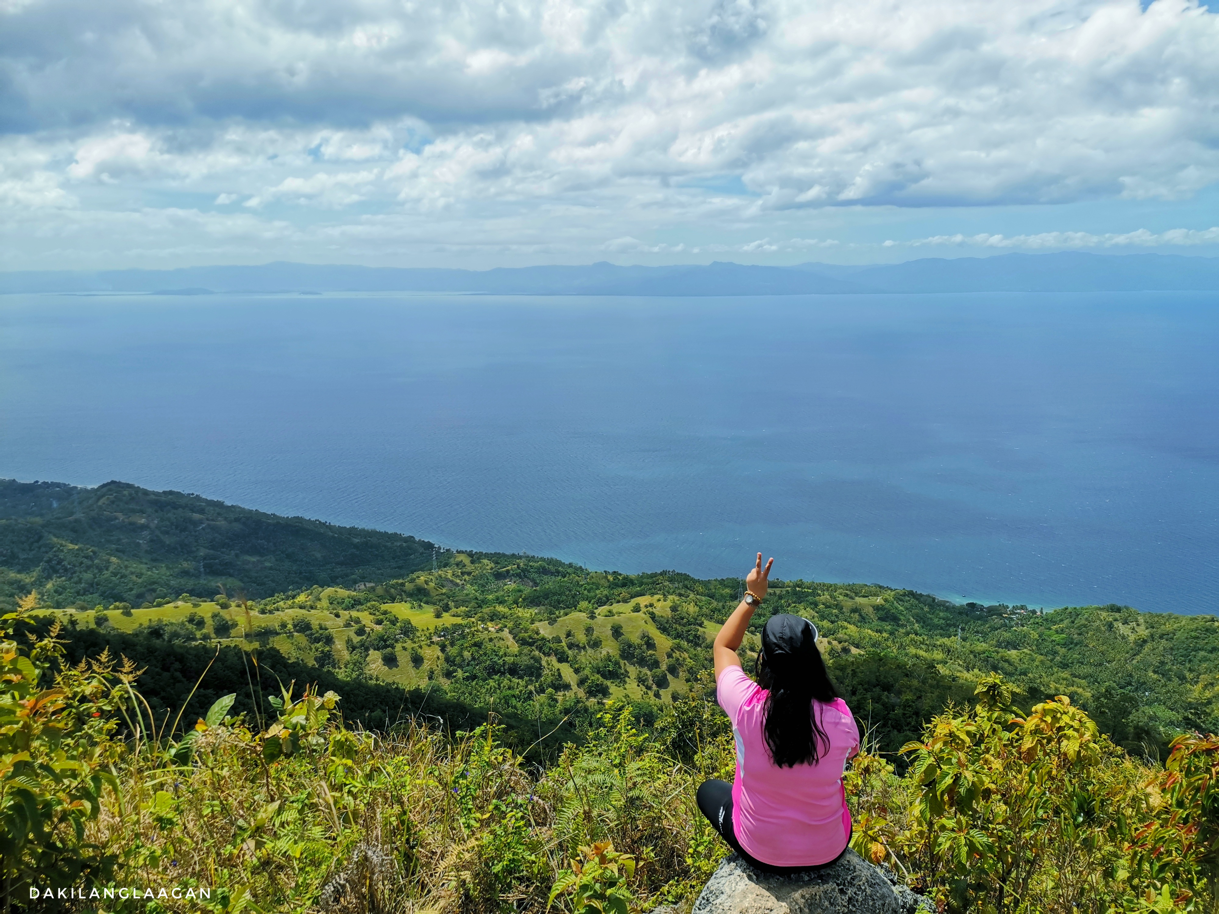
16. Mago Peak
Nestled along the borders of Danao, Carmen, and Tuburan in Cebu, Mago offers an enchanting escape into nature’s embrace. The mountain’s verdant slopes and winding trails beckon adventurers seeking solitude and serenity amidst breathtaking landscapes. Its open trail, reminiscent of the iconic Windows Vista wallpaper, invites travelers to immerse themselves in the boundless beauty of nature.
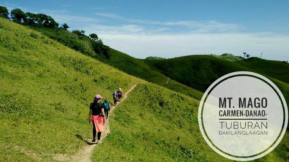
Where is Mago Located?
Boundaries between Carmen, Danao and Tuburan
How to Get to Mago?
(1) Start your journey by riding a jeepney bound for Carmen, Cebu.
(2) Upon reaching Carmen Public Market, take a habal-habal ride to Barangay Santican. Along the way, you’ll pass by MLhuillier’s expansive farms and horse ranch.
(3) Upon arrival in Barangay Santican, register at the Barangay Hall and seek guidance from locals for the trek to the summit of Mago.
*Note: According to locals, Mago is not the name of the area where the boundaries of the three municipalities meet. Instead, it refers to the tree standing atop the peak, visible from various points in the three mentioned places.
Expenses:
To get to Mt. Mago (as most fondly call it), first, board a bus bound for Carmen, which typically costs around P30.00. From Carmen Public Market, secure a habal-habal ride to Barangay Santican, which may range from P80.00 to P100.00. Upon arrival, register at the Barangay Hall and seek guidance from locals for the trek to the summit. Keep in mind that the payment for the guide is negotiable and subject to change without prior notice.
Tips:
From Mt. Mago, you have the option to take side trips to Mangitngit Falls or Durano Ecofarm. Simply inform the habal-habal driver of your choice, and they will transport you to your desired destination.
Read on for More Details about Mago:
17. Mt. Kapayas
Perched between the towns of Carmen and Catmon in Cebu, Mount Kapayas stands as a majestic landmark offering thrilling adventures for outdoor enthusiasts. Known for its rugged terrain and scenic vistas, this mountain promises a rewarding trekking experience. As you ascend its slopes, you’ll be treated to sweeping views of lush landscapes and distant horizons. Whether you’re seeking an adrenaline-pumping hike or a peaceful retreat amidst nature, Mount Kapayas invites you to discover the wonders of its untamed wilderness.
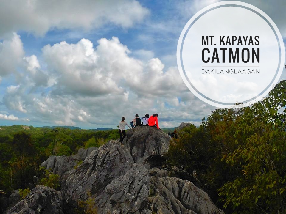
Where is Mt. Kapayas Located?
Catmon, Cebu
How to Get to Mt. Kapayas?
Pre-Requisites: Contact guides certified by the municipality of Catmon. Complete necessary documents for Environmental Fee and registration forms.
Mt. Kapayas lies between the territories of Carmen and Catmon. Opt for the longer and more challenging trail via Catmon if you’re up for it, or choose the easier and shorter trail from Catmon if you’re pressed for time. Either way, both trails lead to the same peak.
Note: Mountaineers are strictly prohibited from hiking and camping in Mount Kapayas without prior notice and permit from the municipal hall. It’s always better to be safe than sorry.
Expenses:
Getting to Mt. Kapayas involves several fees and arrangements. Expect to pay P650 for processing forms and registration, along with a campsite fee of P20. Additionally, allocate P50 for the habal-habal fare to the jumpoff site. For guide services, budget approximately P150 per head. Keep in mind that these prices are subject to change without prior notice.
Tips:
After conquering Mt. Kapayas, you have the option to explore additional attractions nearby. Consider taking side trips to Mangitngit Falls or Durano Ecofarm. Simply inform the habal-habal driver of your desired destination, and they will transport you accordingly.
Read on for More Details about Mt. Kapayas:
Mt. Kapayas: A Letter from the Mountain
18. Mt. Manghilao
Nestled in Danao, Mt. Manghilao boasts a captivating sight—a cross adorning its summit, casting a serene aura over the landscape. This symbolic landmark offers a peaceful sanctuary for hikers seeking solace amidst nature’s embrace. As you ascend its trails, the allure of Mt. Manghilao beckons, promising both spiritual renewal and awe-inspiring vistas of Danao’s picturesque terrain.
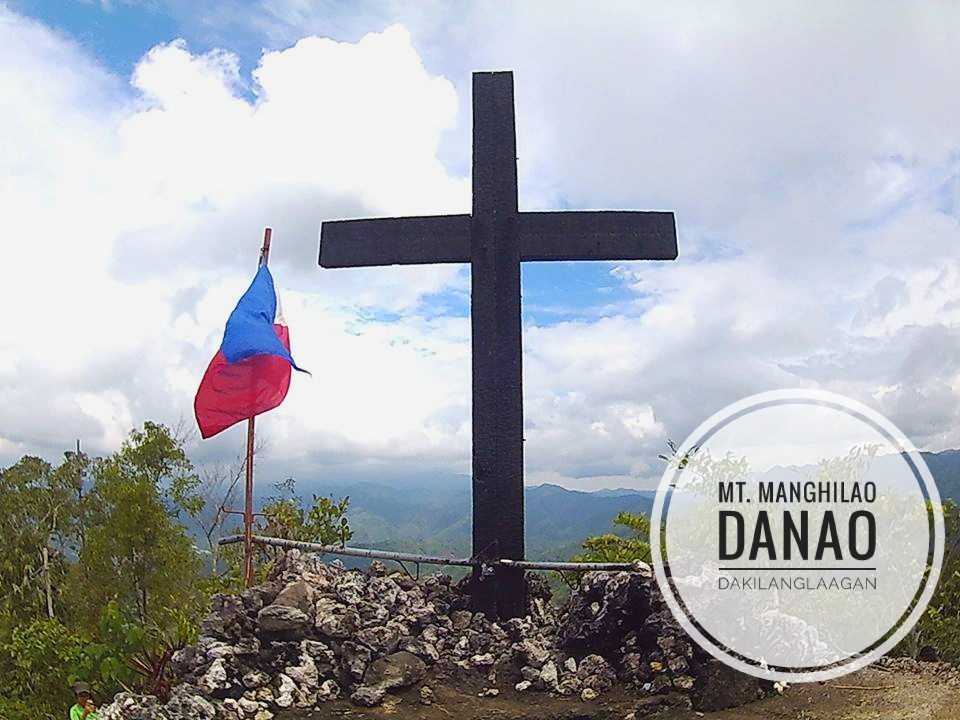
Where is Mt. Manghilao Located?
Danao City, Cebu
How to Get to Mt. Manghilao?
Begin your journey by riding a bus bound for Danao City. Upon arrival, hire a habal-habal or take a jeepney to Barangay Masaba. Once in Barangay Masaba, seek assistance from the locals to guide you to Mt. Manghilao. With these steps, you’ll be all set to embark on your adventure to Mt. Manghilao.
Expenses:
Prepare for your journey to Mt. Manghilao by budgeting P40 for the bus fare to Danao City. Upon reaching Danao City, allocate an additional P20 to P50 for the habal-habal fare to Barangay Masaba, where your trek begins. Note that prices and fares may change without prior notice.
Alternatively, you can participate in the annual MagMa Trail Run, which includes a portion of the route passing through Mt. Manghilao.
Tips:
After reaching the peak of Manghilao, you have two options for additional exploration. You can either trailblaze to a densely populated cave near the summit or choose to visit Durano Ecofarm. For those intrigued by hidden caves, some outdoor enthusiasts suggest contacting local officials at the Barangay Hall for more information and assistance.
Read on for More Details about Mt. Manghilao:
MagMa Trail Run 2022: This Is Where It All Ends
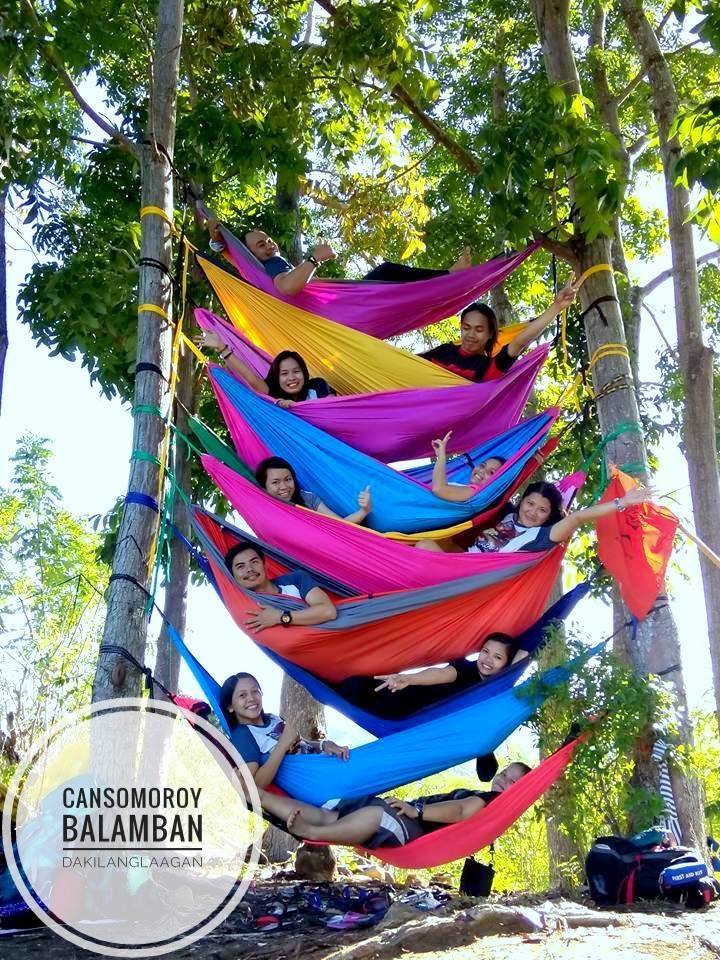
19. Cansomoroy
Cansomoroy serves as the picturesque border between Balamban and the rest of Cebu, marking the transition from the bustling urban areas to the serene countryside. This quaint barangay offers a peaceful retreat with its lush landscapes, rolling hills, and scenic vistas, providing a refreshing escape from the urban hustle. As you traverse through Cansomoroy, you’ll be greeted by charming rural scenery, inviting you to explore its natural wonders and immerse yourself in the tranquility of the countryside.
Where is Cansomoy Located?
Balamban, Cebu
How to Get to Cansomoy?
Here’s how to get started. First up, hop on a v-hire or grab a habal-habal to get you there. It’s a pretty convenient ride, and you’ll get to enjoy the scenery along the way. Once you arrive, head over to the Barangay hall. That’s where all the action happens! You can register there and even chat with the local officials to get some tips and maybe even find a guide to show you around.
Expenses:
To kickstart your adventure in Barangay Cansomoroy, budget around P120 for the fare via Transcentral Highway. Once you arrive, don’t forget that the guide fee is negotiable, so you can discuss rates with your guide based on your preferences and the complexity of your trek. Fare may subject to change without prior notice.
Tips:
Exploring Barangay Cansomoroy offers exciting opportunities to immerse yourself in nature. Don’t hesitate to ask your guide to take you to the nearby caves and waterfalls, tucked away amidst the lush vegetation of Cansomoroy. If you’re up for it, camping and hammock parties are very much welcomed in the area—just remember to adhere to the Leave No Trace principles at all times to preserve the natural beauty of the surroundings.
Since you’re already in the vicinity of Balamban, consider extending your adventure by visiting attractions like Canso X, West 35, or all the way to Balamban’s Cambuhawe Spring. These additional destinations promise more adventures and breathtaking views to enhance your trip.
20. Hambubuyog
Mt. Hambubuyog may seem modest in elevation at just 820 MASL, but it offers an adventure worth exploring. As you embark on the trek to its summit, be prepared for a challenging yet rewarding journey. Along the trail, take a moment to cool off at the falls, immersing yourself in the refreshing waters. Despite the relatively low altitude, the trek can be demanding, especially under the heat of the sun. Therefore, it’s essential to stay hydrated and wear appropriate gear for the hike.
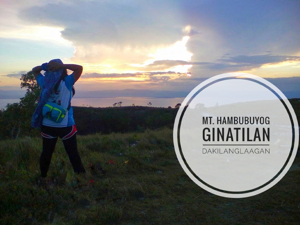
Where is Mt. Hambubuyog Located?
Ginatilan, Cebu
How to Get to Mt. Hambubuyog?
For your adventure to Mt. Hambubuyog, there are two thrilling options to choose from: the easy route and the hardcore route. If you’re looking for a more leisurely journey, opt for the Easy Route: simply hop on a bus bound for Samboan and then hire a habal-habal to take you directly to the Divine Mercy chapel atop Mt. Hambubuyog.
On the other hand, if you’re up for a challenge, embark on the Hardcore Route: catch a bus to Ginatilan and then ride a habal-habal to Inambakan Falls. From there, begin your trek from the first level of Inambakan Falls to the third level of Kampael Falls, before embarking on a direct assault up the mountain. While this route may take approximately 5 to 10 hours, locals can guide you through a shortcut, reducing the journey to just 3 to 4 hours, passing through Barangay Hambubuyog’s main water source, a mini-forest, and the Calvary Trail along the way.
Expenses:
For your journey to Mt. Hambubuyog, budget approximately P150 for the bus fare to either Ginatilan or Samboan, depending on your chosen route. Once you arrive, expect to pay around P75 for a habal-habal ride to and from the Divine Mercy Chapel if you’re taking the Easy Route, or P50 for a habal-habal to Inamabakan Falls if you’re opting for the Hardcore Route. Additionally, there’s a nominal entrance fee of P10 at Inamabakan Falls. Note, prices and fares may be subject to change without prior notice, so it’s always a good idea to double-check before your trip.
Tips:
After reaching the summit of Mt. Hambubuyog, you’ll encounter a fork in the road, offering two distinct paths. If you head towards Oslob, you’ll have the opportunity to explore the picturesque Salamanca Hills and marvel at the breathtaking beauty of Tumalog Falls. On the other hand, if you choose the route leading to Samboan, you can enjoy a sidetrip to both Candayvic Falls and Dau Falls, where you can immerse yourself in the tranquil ambiance of nature and revel in the cascading waters. Whichever path you decide to take, prepare for an unforgettable journey filled with stunning landscapes and serene surroundings.
Read on for More Details about Mt. Hambubuyog:
Mt. Hambubuyog: Stereotypes of Women on Hikes
21. Mercado’s Peak
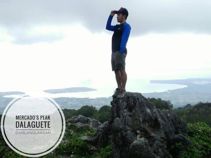
Where is Mercado’s Peak Located?
Badian, Cebu (best accessible through Mantalongon, Dalaguete)
How to Get to Mercado’s Peak?
Nestled within the Osmeña Peak Range, Mercado’s Peak stands as a favored camping spot among both locals and avid hikers who frequent the area. To begin your adventure, head to Cebu South Bus Terminal and hop on a bus bound for Dalaguete. Once there, seek out a habal-habal driver who can transport you to the drop-off junction leading to Mercado’s Peak.
Expenses:
To embark on your journey to Mercado’s Peak, allocate approximately P100.00 to P120.00 for the bus fare from Cebu South Bus Terminal to Dalaguete. Upon reaching Dalaguete, budget around P100.00 for a habal-habal ride that will take you directly to Mercado’s Peak. Remember, fares are subject to change without prior notice, so it’s advisable to confirm the current rates before your trip.
Tips:
To reach Mantalongon, Dalaguete directly from Cebu City, catch a bus stationed at Caltex Gasoline Station in Carbon. While the fare is more affordable, note that air-conditioned buses are currently unavailable. Once you arrive, keep in mind that there’s no fixed fee for guideship. You can negotiate the rates using your haggling skills, ensuring you get the best deal for your hiking expedition.
22. Casino Peak/ Lugsangan Peak
Casino Peak is a must-visit hike in Dalaguete, Cebu, deserving a top spot on your bucket list. It’s my personal favorite among Cebu’s hikes. In this guide, I’ll cover everything you need to know about exploring Casino Peak. Additionally, nearby hikes like Kandungaw Peak, Lovers Peak, and Sunset Peak are gaining popularity among adventurous travelers, offering alternative options to beach destinations.
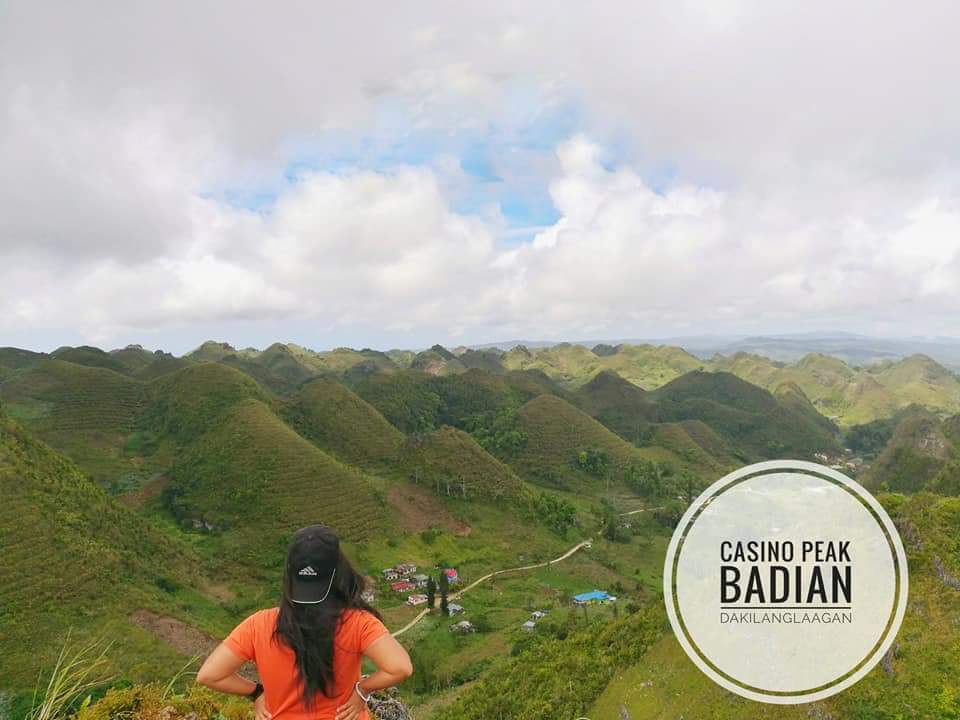
Where is Casino Peak (Lugsangan Peak) Located?
Badian, Cebu
How to Get to Casino Peak (Lugsangan Peak)?
To begin your journey to Casino Peak, head to Cebu South Bus Terminal and catch a bus bound for Dalaguete. Upon arrival in Dalaguete town proper, hop on a habal-habal to reach the jump-off site of Casino Peak.
Once there, you can choose to hire a guide for assistance or tackle the hike on your own. Keep in mind that the path to the summit involves steep terrain and may require technical rock climbing skills. Summit at your own risk, but don’t forget to enjoy the stunning views awaiting you at the top!
Expenses:
Get ready for your journey to Casino Peak by budgeting around P100.00 to P120.00 for your bus fare from Cebu to Dalaguete. Once you’ve arrived in Dalaguete, set aside about P75.00 to P100.00 for a habal-habal ride to take you to the starting point of your trek. Keep in mind that these prices may vary and could change without warning, so it’s wise to have some extra funds just in case.
Tips:
Check out the tips for Osmena Peak and Mercado’s Peak.
If you’re already at Osmena Peak, consider using the exit trail to reach Kawasan Peak. Interestingly, the trail to Kawasan Peak is the same path used to access Casino Peak. Many travelers have unwittingly passed by Casino Peak without realizing the stunning views it offers.
Read on for More Details about Casino Peak (Lugsangan Peak):
Casino Peak: One of the Most Photogenic Mountains in Cebu
23. Tagaytay 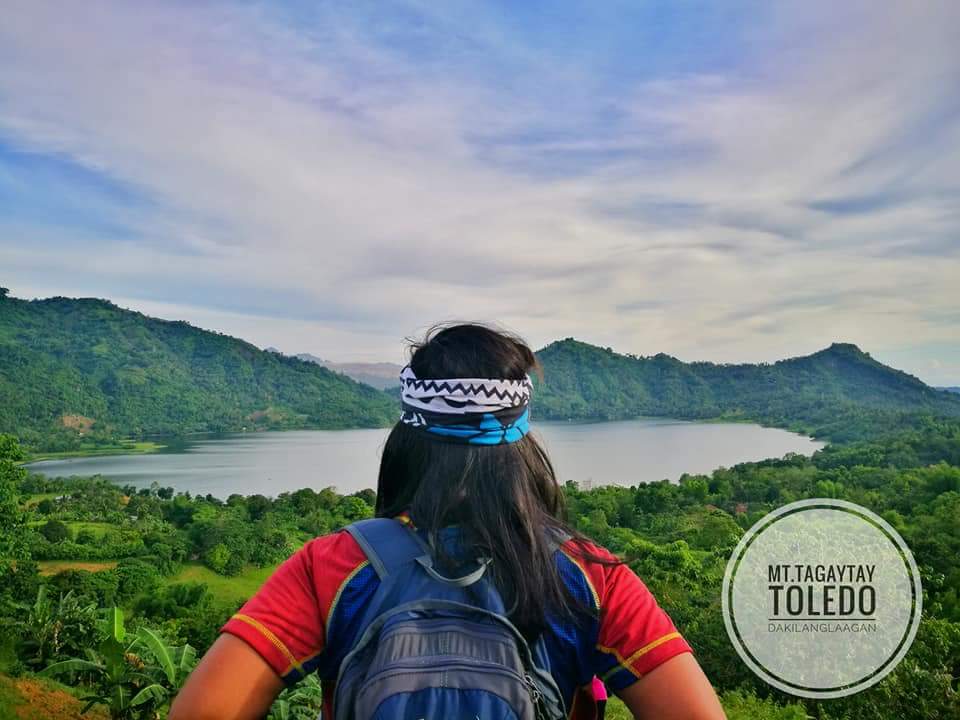
Where is Tagaytay (Toledo) Located?
Barangay Climaco, Toledo City
How to Get to Tagaytay (Toledo)?
Catch a bus from Cebu South Bus Terminal heading to Toledo City. Request the driver to let you off at Julie’s Bakeshop in Barangay Magdugo. Hire a habal-habal to take you to Casoy Barangay Hall. Find a local who can show you the way to Tagaytay Hill.
Expenses:
For your journey, allocate around P50.00 for the bus ride to Toledo and another P50.00 for a habal-habal trip to Casoy Barangay Hall. Prices and fares may be subject to change without prior notice.
Tips:
For additional adventures, consider visiting Malubog Lake and Udlom Peak nearby.
Read on for More Details about Tagaytay (Toledo):
Picture Perfect Peak with Awe-inspiring Panoramas
Malubog Lake: Creating Ripples of Love, Understanding, Positivity
24. Candongao/ Kandungaw Peak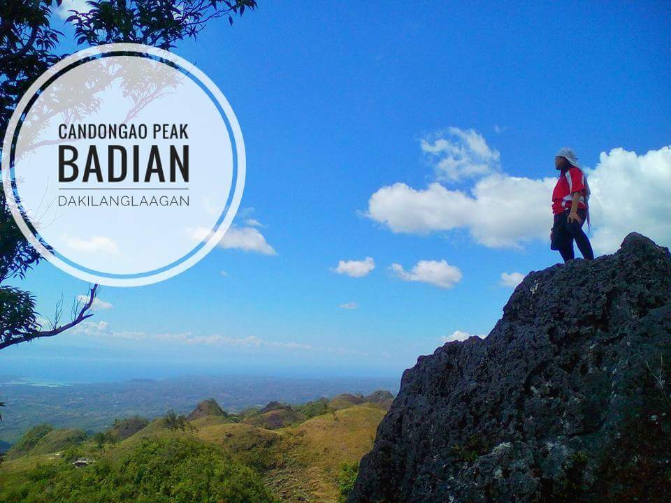
Where is Candongao Peak (Kandungaw Peak) Located?
Badian, Cebu
How to Get to Candongao Peak (Kandungaw Peak)?
(1) Catch a bus from Cebu South Bus Terminal heading to Dalaguete.
(2) Find a habal-habal driver who can take you to the drop-off point for Candongao Peak.
(3) Decide if you want a local guide for assistance, or follow the trail independently to reach the peak.
Expenses:
Prepare approximately P100.00 to P120.00 for a bus ride to Dalaguete and allocate another P100.00 for a habal-habal journey to Candongao Peak. Keep in mind that prices and fares are subject to change without prior notice.
Tips:
To reach Mantalongon, Dalaguete, catch a bus directly from Cebu City at the Caltex Gasoline Station in Carbon. While there’s no fixed fee for guideship, you can negotiate with the guides. For a more challenging trek, consider the Badian Trail, which typically takes 3-4 hours, depending on your group’s pace.
Read on for More Details about Candongao Peak (Kandungaw Peak):
Candongao Peak: The Art of Leaving
25. Pandung Bato/ Batuga’g Banog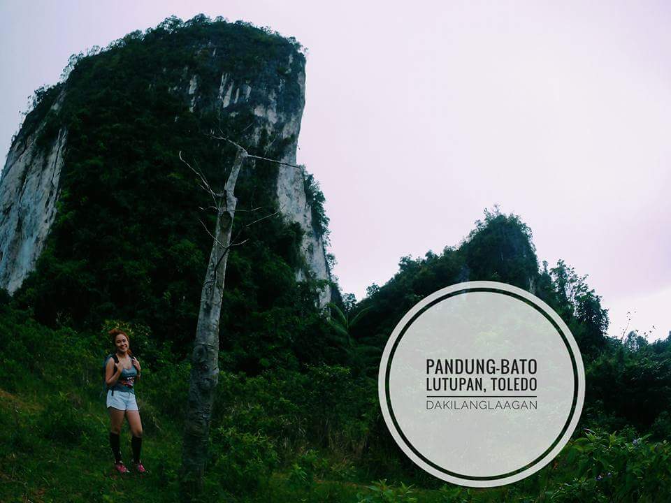
Where is Pandung Bato (Batuga’g Banog) Located?
Toledo City, Cebu
How to Get to Pandung Bato (Batuga’g Banog)?
To start your journey, take a bus headed for Toledo City. Once there, request the driver to let you off at Toledo Landing. From here, seek guidance from locals on how to find Pandong Bato, also known as “Batugag Banog,” named for its frequent visits by brahminy kites in the past.
Expenses:
The bus fare to Toledo Landing typically costs around P50, but keep in mind that prices and fares are subject to change without prior notice.
Tips:
Ensure you have a guide for the steep ascents and semi-rock climbing trails to the summit. Avoid proceeding with the activity if it’s raining.
26. Camari Hill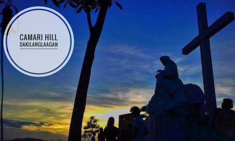
Where is Camari Hill Located?
Camari, Carcar City, Cebu
How to Get to Camari Hill?
To reach Camari Hill, first, take a bus to Carcar City, then hire a habal-habal near Arbie’s Bakeshop at the Rotunda. Ask the driver to transport you to Camari Hill, and you can request to be taken directly to the peak. Don’t miss the opportunity to attend mass at the summit on the first Sunday of every month, especially during sunset.
Expenses:
Bus fare to Carcar City is around P60.00, and expect to pay approximately P50.00 for a habal-habal ride to Camari Hill. Keep in mind that prices and fares are subject to change without prior notice.
Tips:
The location of Camari Hill is ideal for sunset viewing, and there’s plenty of space available for camping if you’re interested in an overnight stay.
Read on for More Details about Camari Hill:
Camari Hill: Pilgrims on a Journey
27. Calibasan
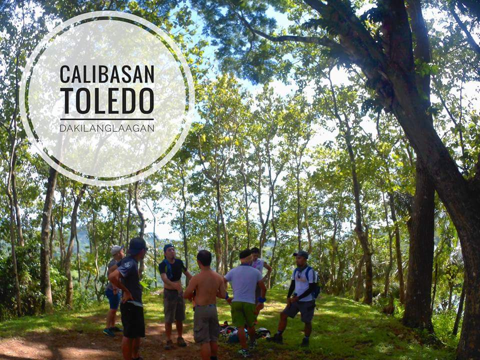
Where is Calibasan Located?
Toledo City, Cebu
How to Get to Calibasan?
Take a bus heading to Toledo City. Request to be dropped off at Barangay Minos. Hire a habal-habal driver to reach the jumpoff point for Calibasan.
Expenses:
Bus fare to Toledo City costs P40.00, while the habal-habal fare to the jumpoff site is around P50.00. Keep in mind that prices and fares may be subject to change without prior notice.
Read on for More Details about Calibasan:
Calibasan with Sagoy Outdoor Group: Getting Lost with the Monkeys
28. Mt. Binalabag
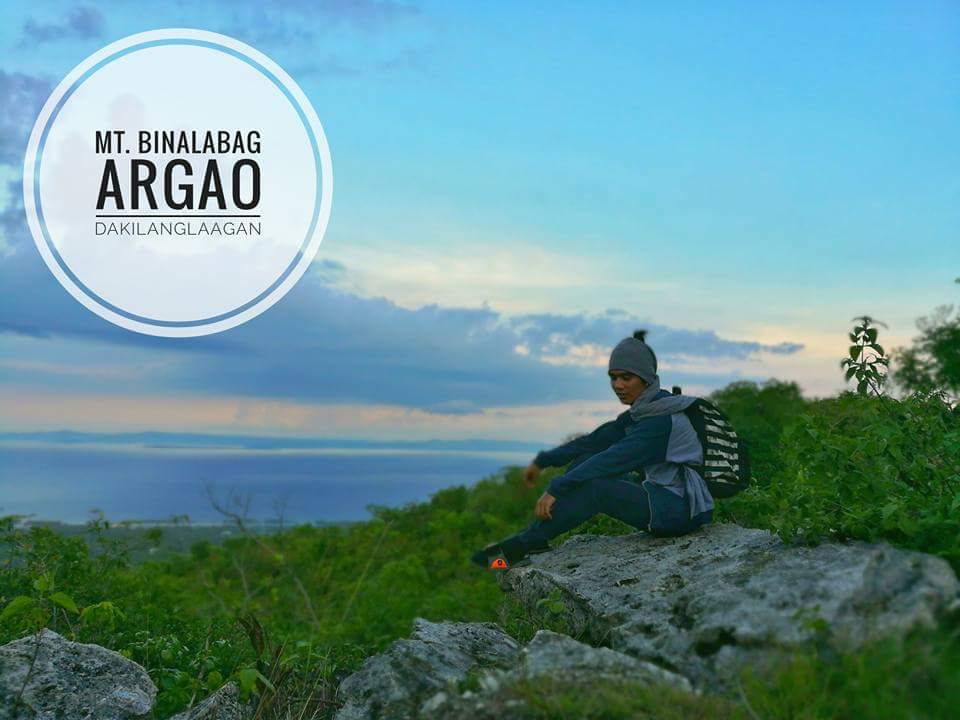
Where is Mt. Binalabag Located?
Argao, Cebu
How to Get to Mt. Binalabag?
To get to Mt. Binalabag, start by taking a bus bound for Argao. Once you’re in Candabong, identified by a waiting shed near a chapel, hire a habal-habal to Barangay Jampang. From there, either request to be dropped off at the jumpoff site or proceed directly to the peak.
Expenses:
To get to Binalabag summit, take a bus to Argao for around P80.00. Upon arrival, hire a habal-habal for approximately P70.00 to reach the summit. Keep in mind that prices and fares may vary and are subject to change without prior notice.
Read on for More Details about Mt. Binalabag:
Mt. Binalabag: Hiking Hacks to Beat the Heat
29. New Bucao
Where is New Bucao Located?
Barangay General Climaco, Toledo City
How to Get to New Bucao?
To reach Mt. New Bucao, first, catch a bus headed for Toledo City. Upon arrival at Barangay Magdugo, ask the driver to drop you off near Julie’s Bakeshop. From there, hire a habal-habal to transport you to Manutu River. Once at the river, seek assistance from a local to guide you to Mt. New Bucao.
Expenses:
To get to Mt. New Bucao, expect to pay around P60.00 for the bus fare to Toledo and approximately P100.00 for a habal-habal ride to Manutu River. Additionally, budget P50.00 for another habal-habal ride to Magdugo. Keep in mind that prices and fares may vary and are subject to change without prior notice.
Tips:
For an adventure to New Bucao, you have two trail options: either from Casoy’s Barangay Hall or via Manutu River. Pick the trail that matches your hiking abilities. And always remember, never underestimate the mountains.
Read on for More Details about New Bucao:
New Bucao: A Gritty, Muddy Uphill Climb to Toledo’s Unsung Mountain
30. Ablayan Peak
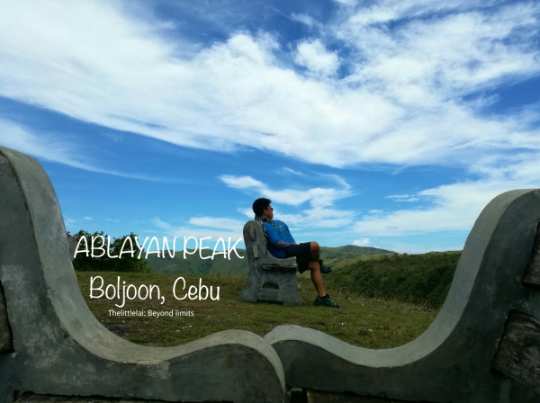
Where is Ablayan Peak Located?
Boljoon, Cebu
How to Get to Ablayan Peak?
To reach Ablayan Peak, simply board a bus headed for Boljoon. Upon arrival, ask the bus conductor to let you off at the Boljoon public market, where you can then hire a habal-habal driver to take you directly to Ablayan Peak.
Expenses:
To get to Ablayan Peak, expect to pay around P150.00 for the bus fare to Boljoon, and another P150.00 for a habal-habal ride to the peak. Keep in mind that prices and fares may vary, and are subject to change without prior notice.
Tips:
For a side trip, consider visiting Dayhag Falls. Keep in mind that there are no shaded areas at the summit, so it’s important to plan your visit for a time of day when the sun isn’t too harsh.
Read on for More Details about Ablayan Peak:
Ablayan Peak: Boljoon’s Natural Park in the Sky
Ablayan Peak: An Enthralling and Windy Summit in Boljoon
31. Danasan Peak
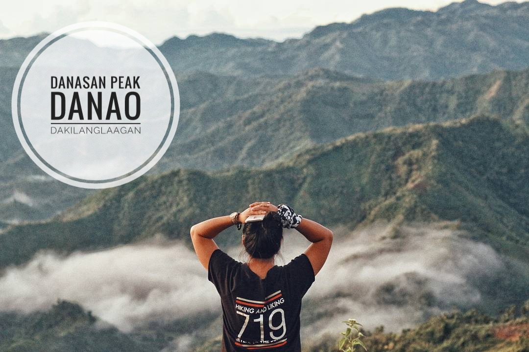
Where is Danasan Peak Located?
Danao City, Cebu
How to Get to Danasan Peak?
To get to Danasan Eco Park, first, take a bus headed to Danao. From there, hire a habal-habal to Barangay Danasan. Alternatively, consider opting for a tour package offered by Danasan Eco Park Adventures, which includes transportation from Cebu City to the park, making your journey hassle-free.
Expenses:
Bus fare to Danao ranges from P60.00 to P100.00, while a jeepney ride from SM to Danao costs around P60.00. Once in Danao, hire a habal-habal to take you to Danasan for approximately P150.00. Remember, prices and fares may vary and are subject to change without prior notice.
Read on for More Details about Danasan Peak:
Danasan Falls and Peak: Exploring Danao’s Majestic Natural Wonders
32. Spartan Trail
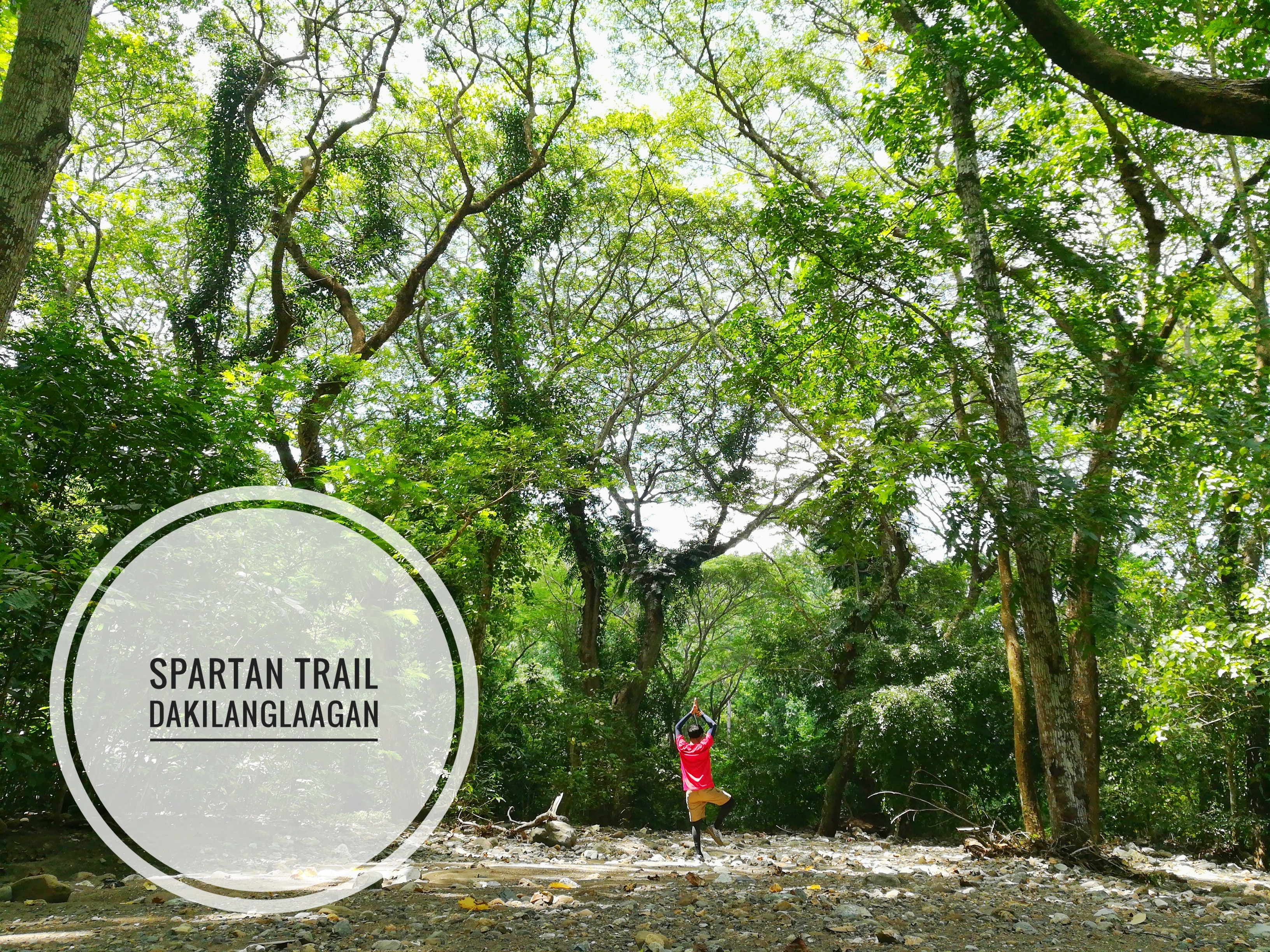
Where is Spartan Trail Located?
Banawa, Cebu City traverse to Barangay Pamutan
How to Get to Spartan Trail?
The hike begins at Celestial Garden in Banawa, and then continues with a direct ascent to Monterrazas de Cebu. From there, descend to Buhisan Watershed before traversing to Barangay Pamutan. Alternatively, from the water source, you can opt for the shorter route leading to Baksan, then proceed to Guadalupe and Tisa.
Expenses:
Jeepney ride to Convergys Banawa – fare varies on your starting point. From Barangay Pamutan, you can either back trail to Banawa (jump off), or ride a habal-habal to Tisa (P150) or Guadalupe (P200).
Tips:
Make sure to bring enough supply of water for the hike and prepare yourself for the steep ascents along the trail. Starting early, around 4am or 5 am, is highly recommended to avoid direct exposure to the sun’s heat.
Read on for More Details about Spartan Trail:
Spartan Trail: Farewell To Cebu City’s Favorite Hiking Destination?
33. Udlom Peak 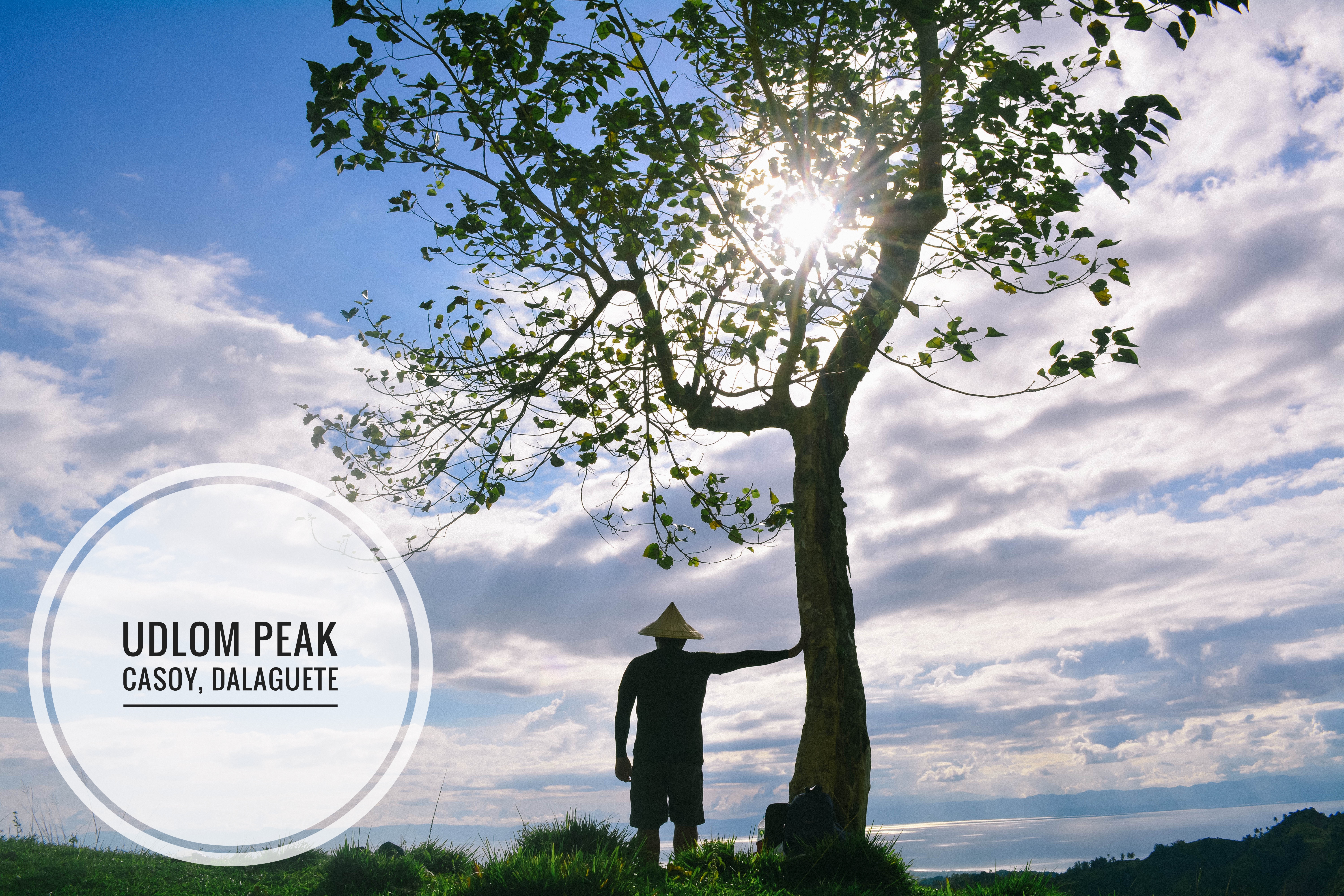
Where is Udlom Peak Located?
Casoy, Dalagauete
How to Get to Udlom Peak?
Take a bus heading to Toledo City. Request the bus driver or conductor to stop near Julie’s Bakeshop close to Barangay Magdugo. Hop on a habal-habal to Casoy Barangay Hall. Arrange for a local guide to lead you to Udlom Peak.
Expenses:
Prepare for your journey with a budget of approximately P50.00 for the bus fare to Toledo. Upon arrival, expect to spend around P50.00 for a habal-habal ride to Casoy Barangay Hall. Keep in mind that prices and fares may vary and are subject to change without prior notice, so it’s wise to have some extra cash on hand.
Tips:
As Aldrich from Bisaya Traveler advises, the region is prone to lightning strikes, making it crucial to cancel your hike if the weather doesn’t cooperate.
Read on for More Details about Udlom Peak:
Udlom Peak: A Mysteriously Beautiful Mountain with an Intriguing History
34. Pangilatan Peak
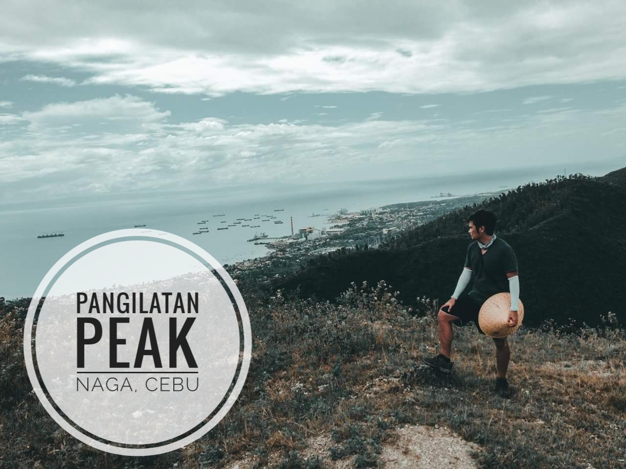
Where is Pangilatan Peak Located?
Naga, Cebu
How to Get to Pangilatan Peak?
To reach Magdook, first, take a jeepney heading to Tungkop, Minglanilla. From there, hire a habal-habal to Sitio Pangilatan. Since the area might not be well-known to locals, ask for directions to Magdook, which is the starting point of the trail.
Alternatively, you can participate in events organized by Tribu Kutod or Pangilatan Unlimited Trail Adventures. Keep an eye on their Facebook page for updates on upcoming events.
Expenses:
To get to Sitio Pangilatan, take a jeepney from Punta Princesa to Tungkop for a fare of P13.00. From Tungkop, expect to pay around P50.00 for the fare to Sitio Pangilatan. Keep in mind that prices and fares may vary and are subject to change without prior notice.
Read on for More Details about Pangilatan Peak:
Pangilatan Peak: An Untouched Summit with 360-Degree Panoramas
35. Magdook
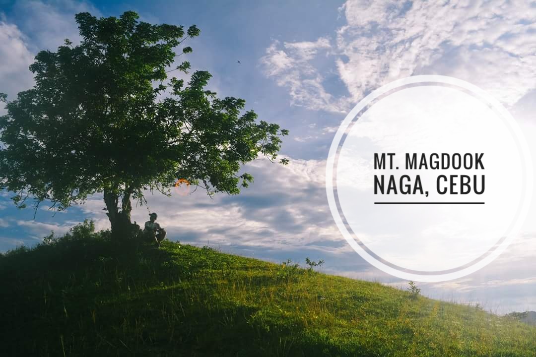
Where is Magdook Located?
Naga, Cebu
How to Get to Magdook?
Please refer to Pangilatan Peak.
Read on for More Details about Magdook:
Mount Magdook: The Art of Hiking Without A Plan in Naga, Cebu
36. Dakung Krus , Compostela
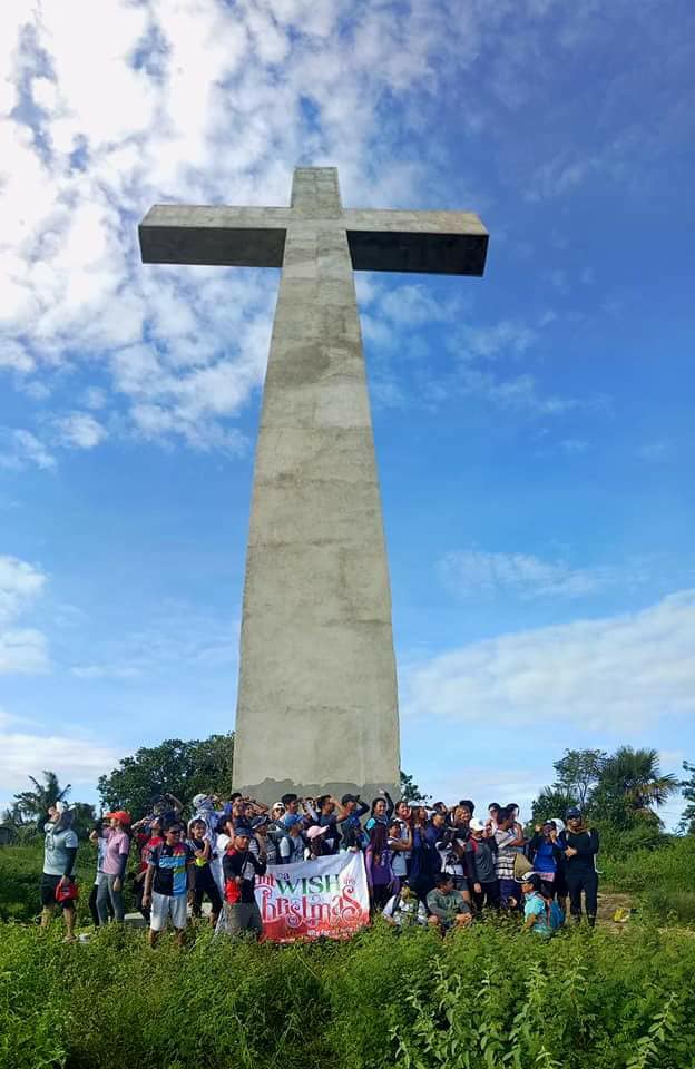
Where is Dakung Krus (Compostela) Exactly Located?
Compostela, Cebu
How to Get to Dakung Krus (Compostela)?
Before starting the hike, first, take a jeepney bound for Danao from SM Cebu. Upon arrival at Compostela Public Market, hire a habal-habal to Dikyop. Once there, begin your hike.
Expenses:
Jeepney fare to Danao is P40.00, while a habal-habal ride to Dikyop costs P20.00. Keep in mind that prices and fares are subject to change without prior notice.
Read on for More Details about Dakung Krus (Compostela):
Holy Cross Compostela: The Most Awe-Inspiring Crucifix I’ve Seen in Cebu
MAD with Team Bang’s Hike for a Cause
There are several other mountains in Cebu worth exploring, like Mt. Kabayoan, Mt. Kangbulagsing, Mt. Lanipga, Mt. Taklian, Mt. Montaneza, Pung-ol Sibugay, and Manuel’s Peak. Additionally, you can find recollection sites nestled in the hills and mountains of Cebu, such as Don Bosco, San Carlos Heights, and Tabor Hills, offering a similar reflective experience for adventurers. Consider adding these destinations to your itinerary – nature might just hold the answers you seek.
PS. Feel free to message me on Facebook, comment below or send me a DM on Instagram should you have further inquiries. If you have a mountain around your area that you want to be featured on Dakilanglaagan’s list, feel free to tell me. To more mountains to hike! Cheers!

See you on trails!
